
Understanding the proposed zoning changes and what they could mean for the village
It’s been 10 days since the new zoning code was *quietly* dropped, and I’ve been digging in to try and understand what’s changed.
160+ pages.
One map.
Zero context.
How are we expected to give feedback on a massive technical document and ask questions without any explanation of “what’s changed” to reference? Where’s the Facebook posts letting you know the code was released and encouraging your feedback and participation on April 3rd?
Cue the crickets.
We have 6 days left before the ONLY scheduled public workshop on April 3rd (50 West High St at 7 PM). I am sharing what I have found in case it may be helpful to anyone else.
Why should you care about zoning?
Zoning code determines…
- What can be built near your home
- Traffic and parking
- Property values
- Local character and charm
- Available green space and parks
Contributor shout out 👏
Thank you to The Ballston Tea’s first contributor, who I will refer to as *Brewster Snipe*, for sending in some excellent interactive maps and data to share with you here.

Index
- Interactive Map
- Historic District/Mayor’s Comment
- Residential Changes
- Parks/Green Space
- Downtown
- Highway
- Industrial
- Mohican Hills
Reference documents
- Existing Zoning Code
- Existing Code – Area and Bulk Requirements Part 1
- Existing Zoning Map
- Proposed Zoning Code
- Proposed Zoning Map
Proposed vs. existing map and district changes
For this first drop, I will be focusing more on the zoning map and sharing observations and tools to help you explore changes and what they may mean for you. A future drop will include additional, more overarching discoveries.
What the interactive map can do
Click and drag the middle slider with arrows to toggle the map between current zoning and new zoning.
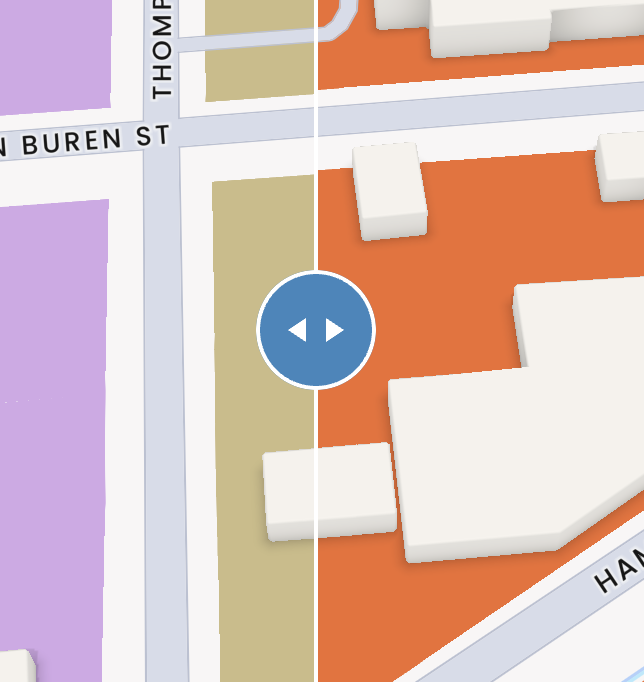
Double click/tap to zoom in and view areas in 3D.
Click on a building to see the zone it’s zone.
Interactive zoning map
References: Current Zoning Map, Proposed Zoning Map
Credit: Brewster Snipe
*Observations*
Historic district overlay removed
The Mayor has stated that the historic preservation part of the code will be solidified later. From his own statements, the removal seems intended – though it is unclear where the decision to remove the overlay came from, or how it will protect historic buildings at the same level or more than they are now. Residents who care about preservation should keep an eye out. Personally, I am a bit worried about this one 📌.
👉 What has the mayor said? 👈
Facebook comments from Mayor related to the historic district. *CLICK TO EXPAND*
It feels weird to reference a Facebook comment, but this was the only documented insight I could find regarding the Mayor’s potential agenda for the Historic District. Ironically, the Mayor left this comment on a post where he was attempting to discredit my page, labeling me as an alarmist group with a paid marketing team. This happened less than 48 hours after I had made a post about the 5K+ new residents that will be moving in just outside the village. It seems he found time to post about my page but couldn’t be bothered to inform residents about the zoning changes. But I’m getting sidetracked…
Facebook post comment was left on
Mayor’s Frank Rossi’s Facebook comment:
“Why do you want to want to make the whole village a historic district and what would that mean for me if I live in the village and am not presently in one now? What’s going to change for us homeowners in the village who will then be in a historic district?”
The intent is twofold with respect to the Historic District and the Commission. Currently, the Historic District encompasses just a few streets of the Village that may have some historic structures/character, but those streets do not hold all of the history of our Village. For instance, Abner Doubleday’s home (which incidentally is owned by the Chairman of the HDC) is not in the HDC. This is one of many oddities that exist.
However, the operation of the HDC has often come into question with respect to how onerous or problematic their functions can be for someone seeking to either perform simple renovations to the exterior of their property (or even construction of a handicapped ramp in the case of one church). There’s a better balance to be achieved between preserving charm, character, and history in our Village while ensuring the property owners have a clear pathway to being able to do things like fix their roof, paint their exterior, fix broken elements, etc. In addition, what we witnessed with respect to the “Beehive Property” (103 East High Street) and the process that some people assumed was the “code-approved” method was nothing short of embarrassing and risked a significant positive investment being made by the current owner renovating a decade-long eyesore.
The new HDC code that is being worked on would accomplish two things. First, it would allow ANY property in the Village to be included as a National Historic Registry property, which would enable the owner to receive tax credits for renovations consistent with the goals of the Parks Department of the State and their Federal counterparts. In other words, every property would not automatically be included, but they would have to be nominated by a body like a Historic District Commission for inclusion.
Second, we are working to eliminate some of the problems being encountered by the current Historic District related to the operations of the Commission. On the one hand, we want to ensure the character of a property or group of properties/neighborhood is maintained. On the other hand, we have seen the disaster the Saratoga Springs Design Review process has become and don’t want an endless process for something as simple as repairing or replacing a roof due to issues being experienced. We are working with NYS Parks to determine the boundaries that they would allow us to operate within to ensure the credits system would remain intact while creating a manageable, understandable process for review and potential approval for applicants that would include our Planning Board and our Historic District Commission with respect to properties in the Registry. That is why this code is currently missing in our draft as we continue to work on how it would work to achieve the balance a lot of folks have raised as necessary after seeing some of the operations of the Historic District create unintended problems.
——————————–
*UPDATE 4/2/05*
Mayor releases AN updated map that adds historic overlay back (day before the public ZONING meeting).
The re-inclusion of the historic district seems to be the only change to the new map. The mayor has stated within his Facebook post that the HDC rules will remain as is in the interim before future changes are determined. Heated sentiment from Planning Board Chairman Rory O’Connor (who will be a part of the final say) in this Facebook post’s comments.
- Updated proposed zoning map with historic overlay re-added
- Mayor’s facebook comment announcing new map
👉 Questions 👈
- Who decided to remove the overlay and why?
- Who will have the final say on design standards and sign-off? Preservationists?
- If the historic protections are not defined by the Mayor’s July deadline, will that leave a gap in coverage?
👉 Considers 👈
- Historic preservation was a top priority gathered from 800+ responses received when residents were asked what was important to them for the comprehensive plan.
- Historic preservation was a top priority collected from resident feedback during the first public zoning workshop in October.
Residential zoning changes seem to promote increasing density
From my own perspective, there are some BIG changes here. Homes that were previously zoned R-1 single-family homes have now been classified under R-1A or R-1B with changes. In some cases, some single-family homes have been moved to R-2.
Overview of whats changed for residential:
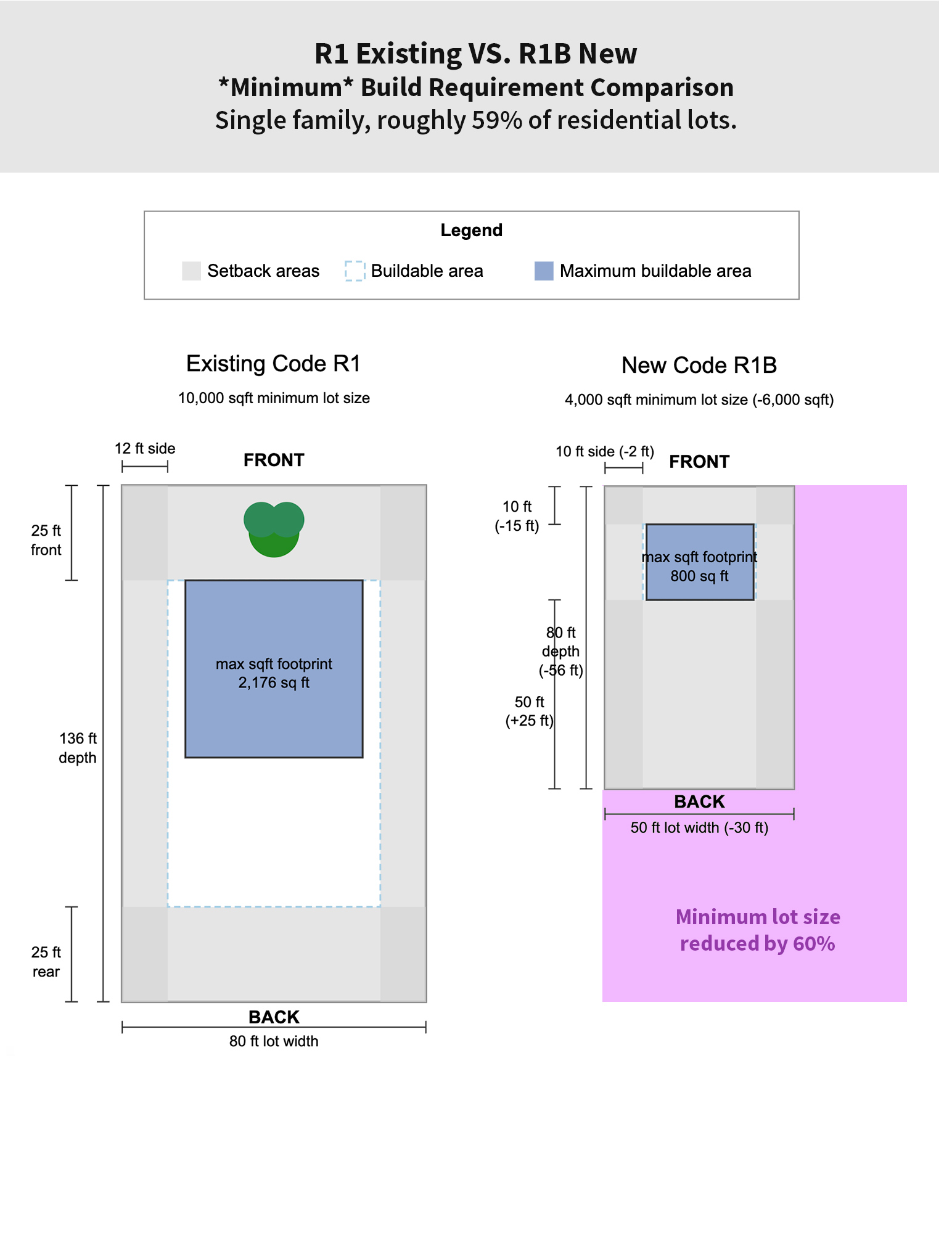
R-1B
(Single family, roughly 59% of residential lots)
- Minimum lot size decreased 6,000 sqft
(updated 3/31 using area and bulk referenced below – previously stated decreased 1,000 sqft) - Minimum width decreased 30ft
- Minimum front setback decreased by 15ft
- Minimum side setback decreased by 2ft
- Minimum rear setback increased by 25ft
Below is a visual comparison of minimum build requirements in R1 existing VS. R1B proposed. The image was generated with AI, which may not be 100% accurate, but these representations should be generally close.
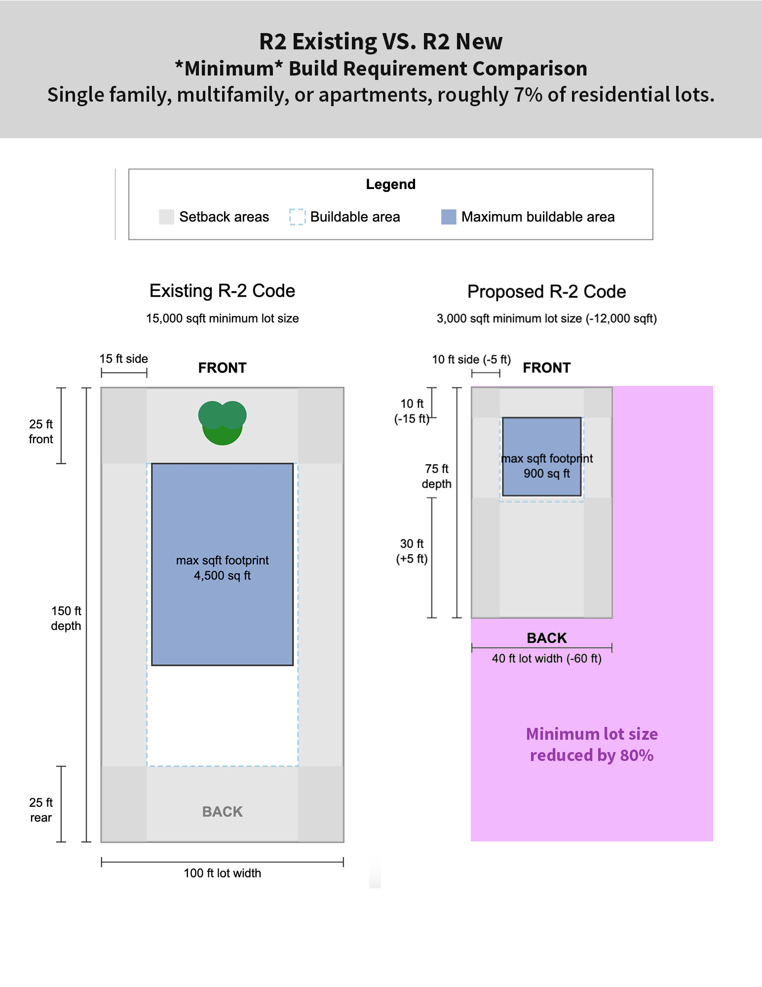
R-2
(Single family, multifamily, or apartments, roughly 7% of residential lots)
- Minimum lot size decreased 12,000-13,500 sqft
- Minimum width decreased from 60ft
- Minimum front setback decreased 15ft
- Minimum rear setback increased 5ft
- Minimum side setback decreased 5ft
(updated 4/2 previously stated increased by +2ft)
Below is a visual comparison of minimum build requirements in R2 existing VS. R2 proposed. The image was generated with AI, which may not be 100% accurate, but these representations should be generally close.
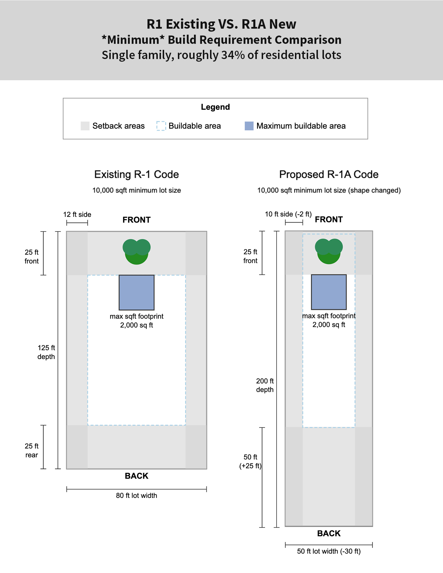
R-1A
(Single family, roughly 34% of residential lots)
- Minimum width decreased by 30ft
- Minimum lot size stayed 10,000 sqft
- Side setback increased by 2ft
- Rear setback decreased by 2ft
Below is a visual comparison of minimum build requirements in R1 existing VS. R1A proposed. The image was generated with AI, which may not be 100% accurate, but these representations should be generally close.
References: Proposed Code (p.27), Existing code (s.205-28), Existing Code Area and Bulk Requirements Part 1
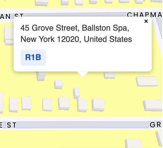
Find your home on the map above and see what zone you land in to compare to the table below. This table pulls from the new plan but adds some additional columns to show what may have changed for your area.
Residential
Front setbacks reduced from 25ft to 10ft
A front setback is “the distance from the front of the building to the property line that runs along the street“. Judging from real estate app property lines, most property lines start inside the sidewalk closest to your building.
👉 Questions 👈
- Who does this benefit?
- Will our street trees become vulnerable now that more will be in buildable areas?
- Will this negatively impact the aesthetics of our streets?
Below was made for a visual representation of the difference between a 25ft and 10ft front setback. The measurement tool on Google Maps was used for scale.

Residential
Minimum lot size reductions increase buildable areas and density
- The required lot size for R1B (majority of single family) decreased from 10,000 sqft to 4,000 sqft. (updated 3/31 – previously stated decreased from 5,000)
- The required lot size for R2 (allows multi family/apartments) previously required 15,000 sqft plus an additional 2,500 sqft for each additional dwelling unit. The new required lot size is 3,000 sqft.
👉 Questions 👈
- Who does this benefit?
- how much could this increase density?
🏗️ R2 Changes: Build baby build 🏗️
- The proposed changes seem to dramatically reduce minimum lot size requirements for both R1B and R2 multifamily/apartment lots. I’ve attached a screenshot of the existing code and reference links below. The minimum lot size requirement for R2 decreased by 12,000-13,500 sqft. See for yourself.
References: Proposed Code (p.27), Existing code (s.205-28), Existing Code Area and Bulk Requirements Part 1

Screenshot from the existing area and bulk requirements.
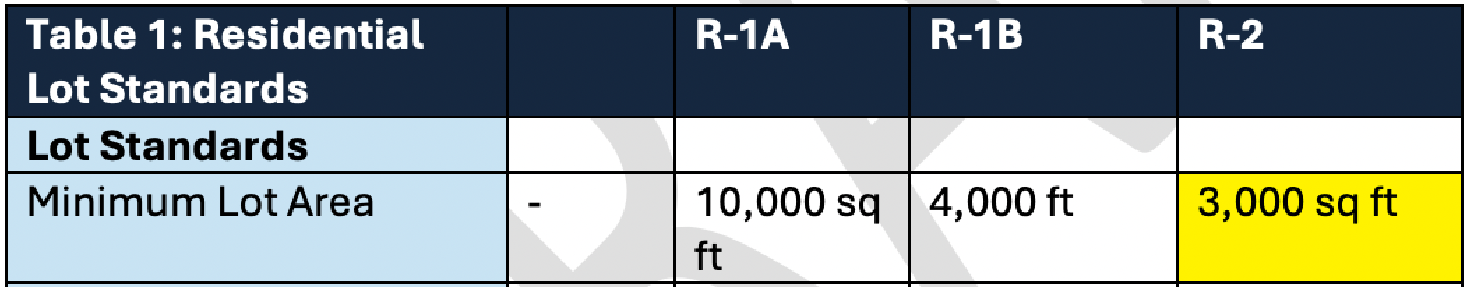
Screenshot from Proposed Code (p.27)
More lots may now meet subdivision requirements; could it be your neighbor?
The dots on the map below represent lots between 8K and 8,999K in sqft. From a sqft perspective, these would not have met subdivision requirements previously but may now. This does not cover all that could now meet requirements as R2 is even less at 6K (minimum 3K lot). Other factors could prevent subdivision, like width, etc.; I am just talking about the sqft criteria here.
Residential Takeaway:
In a time of increasing development pressure from our surrounding area (5K+ moving in within five miles of the village), is now a good time to increase density 🤯?
Map Credit: Brewster Snipe
Parks and green space
Parks zoned as residential. Kelly Park is R2 (multifamily/apartments). Why?
One notable omission in both the current and proposed zoning maps is the formal recognition of public parks and green space. Without this, could they be sold and developed?
This raises concerns about long-term preservation and whether these valuable community spaces are being adequately protected in line with the comprehensive plan’s emphasis on recreation and access to green space.
👉 Questions 👈
- Why is Kelly park and part of Grove St. now zoned R2?
- What was behind the decision to not designate parks as green space?

Central Business District becomes “Downtown” and “Downtown Transition”
The heart of the village is rebranded as “Downtown” and paired with a “Downtown Transition” zone that is applied to many homes that were previously residential (quite a few historic).
👉 Questions 👈
- What are the implications of previously residential homes now being labeled “Downtown Transition”?
- There are many historic homes that now fall within the downtown transition district, will this put our village character at risk?
👉 Considers 👈
- Seems to support expanding businesses further
- Coincides with the removal of the Historic Overlay District — a change that may run counter to the village’s comprehensive plan goals of preserving historic character.
- Could promote mixed-use development and walkability.

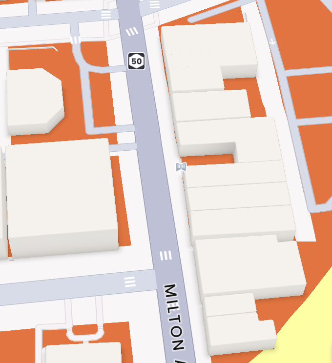
Commercial shifts to “Highway District”
The former Commercial zone, particularly along Route 50, is now labeled “Highway.” While this reflects the corridor’s current auto-oriented character, the change doesn’t do much to support the village’s smart growth goals, such as encouraging walkability or promoting mixed-use development.
👉 Questions 👈
- Will these changes encourage walkability?
- Will changes promote mixed-use development?
- How does this change support the village’s smart growth goals?

Industrial and other zones stay mostly intact
Industrial zones seem to remain largely unchanged with subtle adjustments.
👉 Questions 👈
- Will adjustments in neighboring zones and naming conventions have effects on land use planning?
- How do these shifts support the comprehensive plan’s goals around infrastructure, investment, and sustainability?

R2S becomes “Mohican Hills”
The former R2S zone has been renamed “Mohican Hills,” a name that directly references an existing residential complex. While the area affected is relatively small, the personalized naming of zoning districts raises questions about consistency.
👉 Questions 👈
- What’s up with the naming? Why not be consistent with the rest of the code

*End observations*
Hi, you’re still here? I’m not even sure I’m still here after all of that. I kind of ran out of steam for the last three.
Do me a favor, if you see things that are important to you, show up at the April 3rd workshop at 50 West High St at 7PM.
Malta once underwent a zoning change. The changes allowed for the type of development they have today, and though we’ve all heard complaints about it, I wonder how many residents showed up to their workshops. *taps anxiously awaiting Malta’s Chipotle to be built*
The Mayor has placed an aggressive July 13th deadline to pass a “majority” of the code. It’s not just me who thinks it puts a strain on residents; even our Village lawyer called it extremely tight in the last village meeting. Why put the strain on residents for something so important?
Our officials should be screaming from the roof that zoning is changing, and your time to provide feedback will end very shortly. Do they want your input?
~Brewster
Leave a Reply